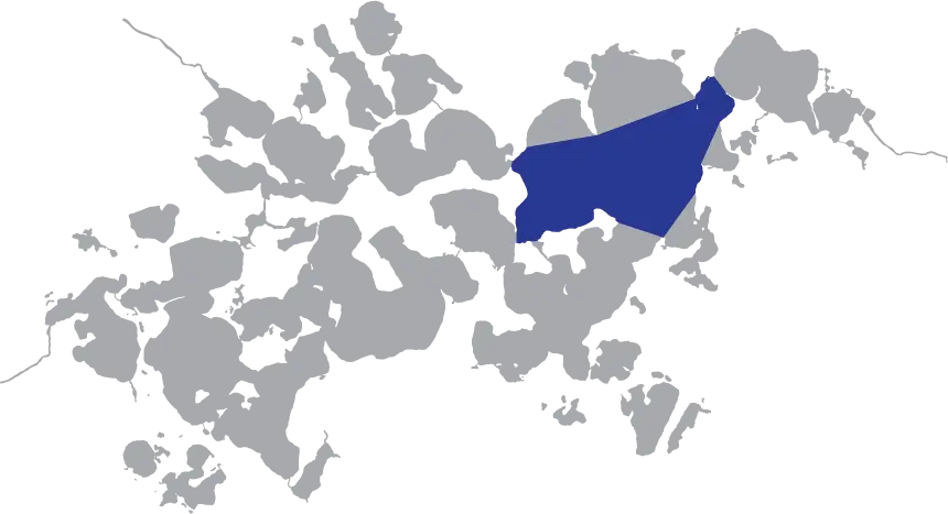
The largest expanse of open water on Lake Minnetonka is the North Lower Lake. Geographically, the Minnesota DNR divides the North Lower Lake into halves: the western portion and the eastern portion, defined by drawing a straight line between Brackett’s Point (Orono) and Swift Point (Deephaven). The North Lower Lake East borders Wayzata Bay to its north, Brown’s Bay to its northwest, Robinson’s Bay to its east, and Carson’s Bay to its southeast. The North Lower Lake West borders Smith’s Bay to its north, Crystal Bay to the west, Lafayette Bay to its southwest, and the South Lower Lake to the south.
The North Lower Lake’s shoreline includes 6 municipalities: Wayzata, Woodland, Deephaven, Minnetonka Beach, and Orono.
Onomatology
The North Lower Lake (East & West) gets its name from its position in the Lake Minnetonka Watershed and its geographical location. “Lower” refers to the portion of Lake Minnetonka in the second half of the watershed before the water moves to Minnehaha Creek. The portions of the Lower Lake that are not specifically named are divided into 3 portions: The North Lower Lake East, The North Lower Lake West, and The South Lower Lake.
History
Being a major portion of the lower lake, The North Lower Lake has several periods and events that have historical significance. Perhaps one of the most known is the operation of The Big Island Amusement Park on Big Island from 1906-1911 –and with it– the golden age of the Twin Cities Rapid Transit street cars and street car boats.
On July 12, 1885, a steam-powered yacht named the Minnie Cook and members from two families got caught in a violet storm that capsized the boat and killed 10 people off the northern shore of the lower lake near Spirit Island. Of the casualties was Alonzo Cooper Rand, owner of the Minneapolis Gaslight Company (now CenterPoint Energy) and former Mayor of the City of Minneapolis. It remains one of the worst accidents to ever occur on Lake Minnetonka.
Besides the Minnie Cook disaster, The North Lower lake was the location of choice for scuttling old boats. There are 4 known vessels on Lake Minnetonka’s floor, just to the north of Big Island’s eastern side.
On the northern border of North Lower Lake Minnetonka where it meets Wayzata Bay is a peninsula named Breezy Point. This point was known as ‘Spirit Knob’ to the Mdewakanton people and had substantial spiritual importance to them. They believed all the power of Lake Minnetonka flowed from that point. Spirit Knob was once a raised bluff, about 25-35 feet in height at the tip of the point with a large tree near its peak. The Mdewakanton would perform sacred rituals on this bluff. It was later eroded and removed because of its lack of structural integrity.